Rangeley Lake
|
|
This article needs additional citations for verification. (December 2009) (Learn how and when to remove this template message) |
| Rangeley Lake | |
|---|---|

postcard ca 1920 | |
| Location | Franklin County, Maine |
| Coordinates | 44°56′50.7″N 70°41′34.6″W / 44.947417°N 70.692944°W / 44.947417; -70.692944Coordinates: 44°56′50.7″N 70°41′34.6″W / 44.947417°N 70.692944°W / 44.947417; -70.692944 |
| Type | mesotrophic |
| Primary outflows | Rangeley River |
| Catchment area | 100 square miles (260 km2) |
| Basin countries | United States |
| Surface area | 6,302 acres (2,550 ha) |
| Average depth | 60 feet (18 m) |
| Max. depth | 149 feet (45 m) |
| Water volume | 291,048 acre·ft (359,002,000 m3) |
| Residence time | 2.6 years |
| Shore length1 | 32.7 miles (52.6 km) |
| Surface elevation | 1,518 feet (463 m) |
| 1 Shore length is not a well-defined measure. | |

Rangeley Lake is located in Franklin County, Maine in the United States. It is fed by several streams. Its waters flow out from the lake's northwestern end into the short Rangeley River, then into Mooselookmeguntic Lake, and ultimately into the Androscoggin River, Merrymeeting Bay, the lower Kennebec River, the Gulf of Maine and the Atlantic Ocean.
The lake is one of the major headwater lakes of the Androscoggin watershed. Its elevation is 1,518 feet (463 m) above sea level and its area is about 10 square miles (26 square km). The lake's depth is shallow near the shore with a central basin averaging about 95 feet (29 m) deep (29 m). The maximum depth is 149 feet (45 m).
It occupies parts of the Franklin County's Minor Civil Divisions of Rangeley and Rangeley Plantation. The town of Rangeley is located on the northeastern shore of Rangeley Lake.
Maneskootuk Island (also called Doctors Island) is in the eastern part of Rangeley Lake. In the western part there is a small group of islands collectively called South Bog Islands.
Rangeley Lake Seaplane Base[edit]
Rangeley Lake has a designated water landing zone for seaplanes (United States Aerodrome M57 – Rangeley Lake Seaplane Base). This aerodrome is one of only a very few[citation needed] aerodromes in the world to be serviced by a GPS instrument approach aligned to a water aerodrome, as well as an NDB approach; almost all other instrument approaches are aligned to runways on land surfaces such as pavement, asphalt, gravel, or turf.[1][2][3][4][5]
Gallery[edit]
-

Rangeley Lake State Park
-
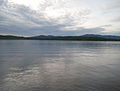
Rangeley Lake from its southern edge, inside the State Park
-
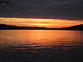
A sunset
-

Rangeley Lake station, ca. 1910


'Maine' 카테고리의 다른 글
| Portsmouth Naval Shipyard (0) | 2017.02.23 |
|---|---|
| 포츠머스 조약 (0) | 2017.02.23 |
| Treaty of Portsmouth (0) | 2017.02.23 |
| Acadia National Park (0) | 2016.05.18 |
| 말코손바닥사슴 (0) | 2016.02.18 |